[Argo Program] How do Argo floats collect oceanographic data in real time?
The Argo program relies on thousands of floats that collect real-time data across the world's oceans. In this article, discover how this program works, learn about the recent contribution of the Tara Ocean Foundation, and understand the importance of international scientific cooperation in better understanding and protecting the Ocean.
Presentation of the ARGO program
What is the Argo project?
The Argo program is an international scientific initiative launched in 2000 by the Intergovernmental Oceanographic Commission and the World Meteorological Organization. It was designed to observe and understand the global Ocean in real time and, in particular, to obtain data on Ocean temperature and salinity in order to monitor its variability and understand its role in the climate system.
This program operates through a network of thousands of Argo buoys, also known as profiling floats. This project is based on a unique collaboration between numerous scientific institutions, including Ifremer in France.
Argo was designed to meet a crucial need: to obtain continuous, reliable, and global data on the state of the Ocean. Unlike traditional oceanographic vessels such as the schooner Tara or satellites, Argo floats are capable of collecting information directly from the water column, from the surface to a depth of 2,000 meters, continuously over long drifts.
Argo is the largest source of ocean data ever collected in human history. It is part of the Global Ocean Observing System (GOOS) and contributes to our understanding of the climate.
Fun fact: The name Argo was chosen in reference to the partnership with the Jason program, the Earth observation satellites responsible for measuring the shape and dynamics of the ocean surface. It is therefore a reference to Greek mythology: Jason sailed on his ship Argo in search of the Golden Fleece.
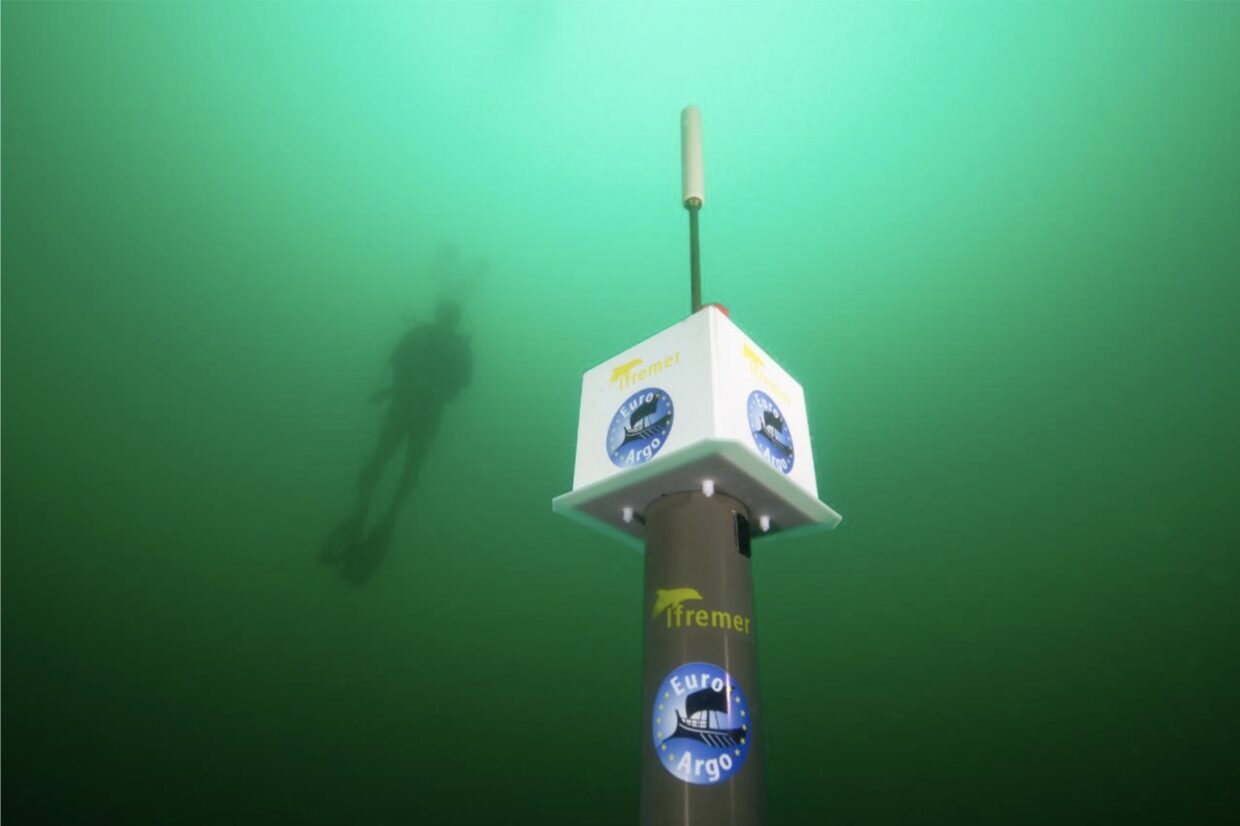
What is an Argo float and what is it used for?
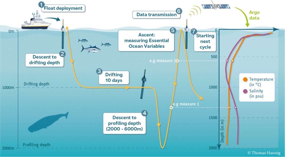
An Argo float is an autonomous scientific instrument designed to drift with the currents. It performs regular cycles of diving to depths of up to 6,000 meters and resurfacing in order to measure temperature, salinity, and sometimes other parameters relating to Ocean biology and chemistry. Once it returns to the surface, it transmits its data via satellite to research centers, which allows global oceanographic databases to be updated in real time.
This information is essential for:
- improving climate models
- monitoring climate change
- better understanding ocean phenomena such as currents and storms
- providing valuable data for navigation and marine weather forecasting
The Argo program aims to maintain an operational fleet of nearly 4,700 autonomous floats spread across all ocean basins. Among them, approximately 1,000 biogeochemical (BGC) floats are equipped with specialized sensors to analyze oxygen, nutrients, and water pH, and 1,200 deep-sea floats are designed to explore depths beyond 2,000 meters.
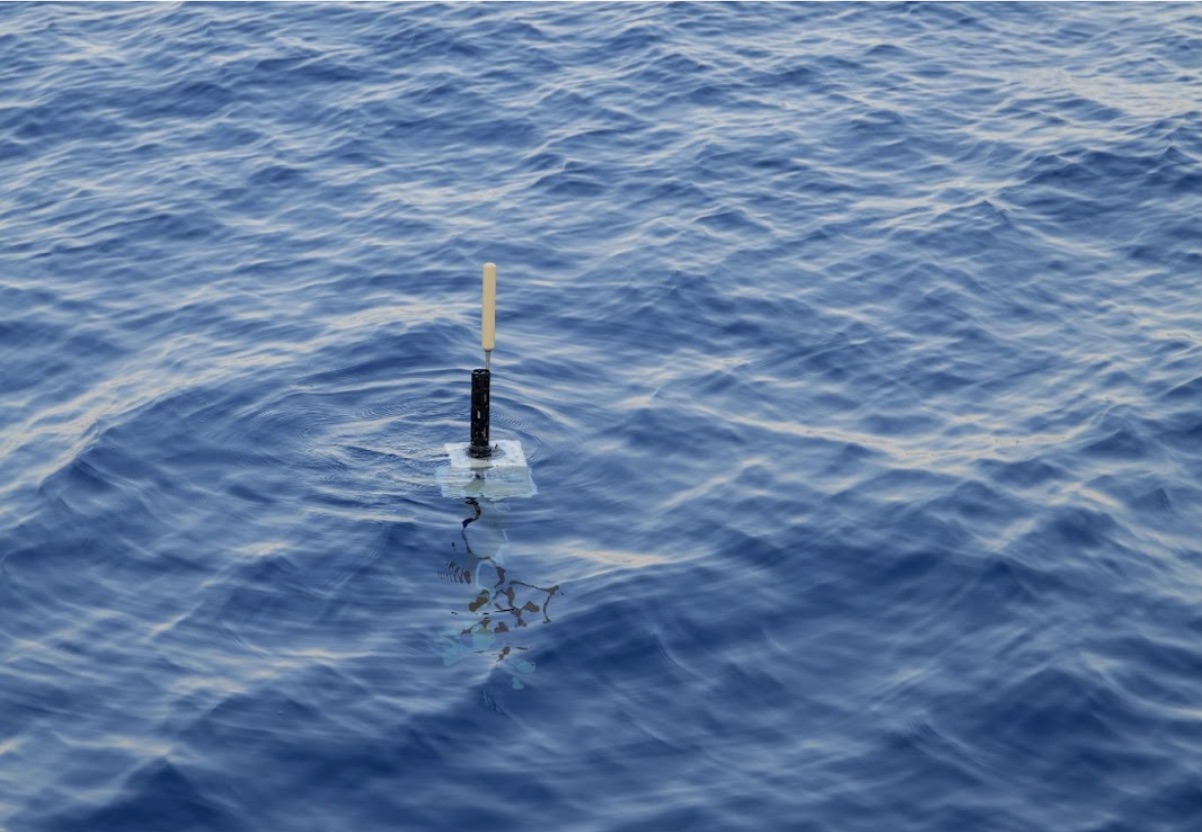
Focus on how the Argo float works
Each Argo profiler is deployed at sea from a research vessel. Once in the water, the float gradually descends to stabilize at a depth of around 1,000 meters. After about ten days, it makes a deeper dive, reaching depths of 2,000, 4,000, or even 6,000 meters, depending on the type. It then begins its ascent to the surface. Once back at the surface, the float automatically transmits its measurements and GPS position via satellite to ground receiving stations. It then dives again to begin a new ten-day cycle until its batteries are depleted, giving it several years of autonomy.
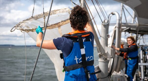
The schooner Tara in search of Argo floats
How has the Tara Ocean Foundation contributed to the Argo program?
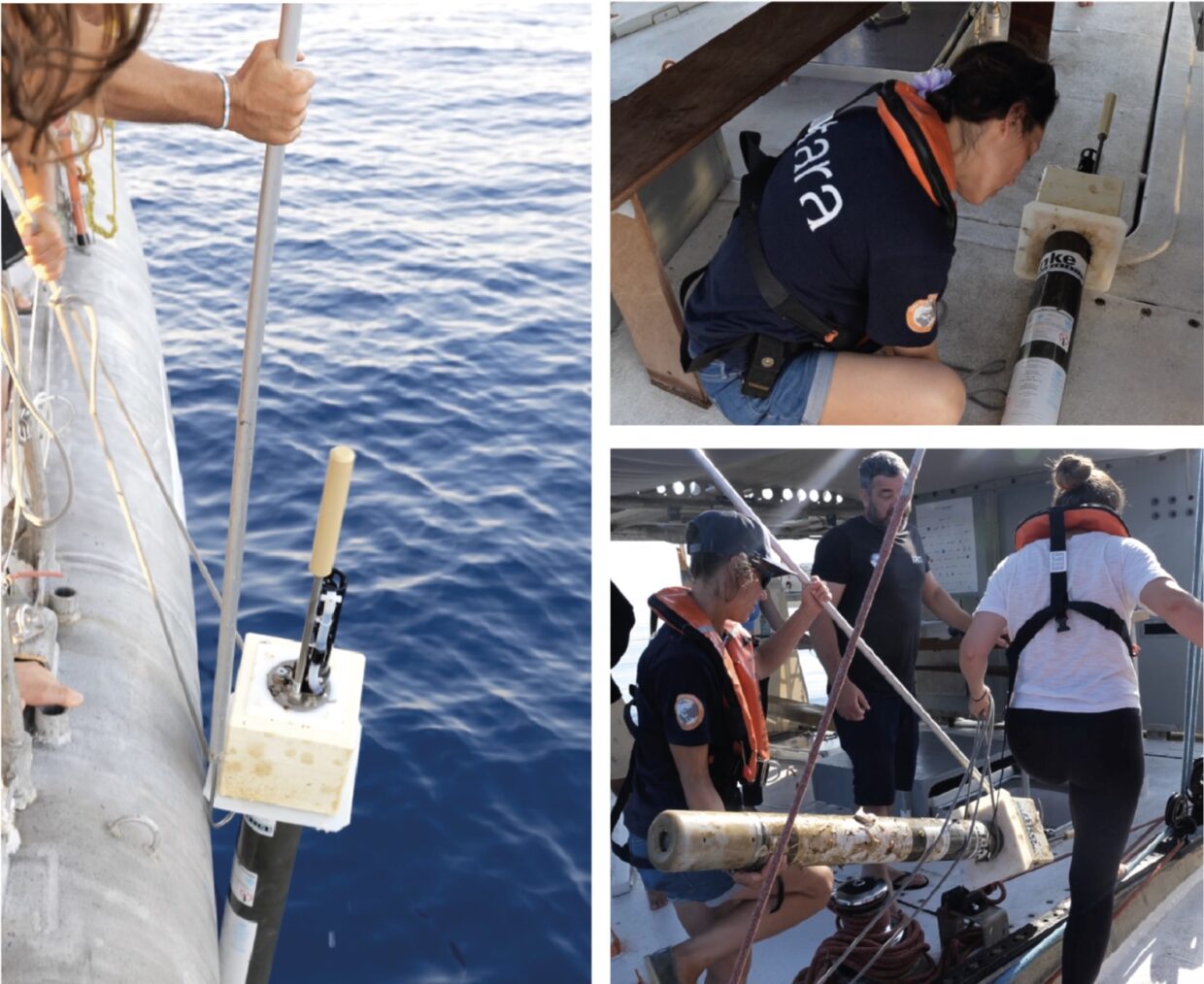
At sea, boats sometimes come across floats that have become inactive. It is essential that these be recovered so that they can be reconditioned and put back into service to continue their mission and continue to contribute to international scientific research.
In this interview, Clémentine Benac talks to Charlène Gicquel, captain of the schooner Tara, about a recent operation during which the crew recovered two Argo floats.
C.B. : Why do Argo floats need to be recovered?
C.G. : These floats are battery-powered and, inevitably, have a limited lifespan of five years on average. So the people who coordinate this program are making increasing efforts to recover the floats when they reach the end of their life to prevent them from ending up as waste in the ocean, since they are equipped with batteries, electronic components, plastic, etc. This is important not only for pollution reasons, but also so that they can be reconditioned and deployed again. This represents a significant saving for all these scientific programs.
C.B. : And why is the schooner Tara going to recover Argo floats?
C.G. : To recover the floats, the program uses ships of opportunity whenever possible. The program coordinators maintain a map of the floats that are on the surface and ready to be recovered, called the “Argo Float Recovery.” So when they see that there is a vessel of opportunity near a buoy, they contact that vessel and offer to recover the float if it is compatible with the vessel’s schedule. This is what happened to us twice in July 2025. The program coordinator at Ifremer contacted us because we were going to pass close to two floats in the Mediterranean that were ready for recovery. They asked us if we would agree to recover them.
What is the process for recovering an Argo buoy?
C.B. : What is the recovery process?
C.G. : Well, the recovery method will differ depending on the vessel, because we don’t all have the same maneuverability. Larger vessels will tend to launch a dinghy or use large nets. On the schooner Tara, we recovered them along the side of the ship, simply because on both occasions the sea was very calm and visibility was excellent, so we were able to locate the float perfectly and approach it directly with Tara and recover it along the side with just a small rope and a boat hook to pull it on board.
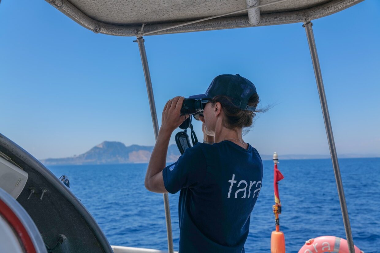
C.G. : And to guarantee our chances of finding the beacon, we track its GPS position in real time! In fact, once it reaches the surface, the Argo float communicates its position via satellite, and that’s when the program coordinator can ask the beacon to send its position at a much shorter frequency so that we can know its position in real time. So that’s what it does once we get close to the area: it increases the position refresh rate to five minutes. That way, every five minutes, we have an updated position, and when we know we’re close, we get out our binoculars and look for it!
Interview with Charlène Gicquel, Captain of the schooner Tara
Scientific collaboration across the global ocean
Why is international cooperation essential for marine research?
Science, and oceanography in particular, cannot progress without international cooperation. The Ocean is a unique and interconnected ecosystem: its dynamics extend far beyond political boundaries.
This is why programs such as Argo rely on a global collective effort. France is among the top three funders, alongside the United States, which contributes approximately 50% of the program’s funding, and Australia. More than 30 nations collaborate to maintain this network of profiling floats, ensuring global coverage and continuous monitoring. This collaboration goes beyond the strictly scientific realm: any ship with an inactive buoy in its path can contribute by recovering it, so that it can be reconditioned and put back into service. This is a concrete illustration of the power of international scientific collaboration.
At the Tara Ocean Foundation, we collaborate with scientists and laboratories around the world. The data collected during our expeditions feeds into a global database that is freely accessible to all, thereby strengthening the sharing of knowledge across the globe.
How does data sharing strengthen science and society?
The strength of the data collected by the Tara Ocean Foundation, the Argo program, and other international initiatives lies in the open access sharing of data. For the Argo program, each measurement collected by a float is quickly transmitted via satellite, validated by scientific teams, and then made available as open data.
This data feeds into:
- fundamental research in climatology and oceanography
- weather and marine forecasts
- public policies for sustainable ocean management
- citizen initiatives
By making information available to the international scientific community, science becomes a collective tool, serving researchers, decision-makers, and civil society.